Get the latest Science News and Discoveries

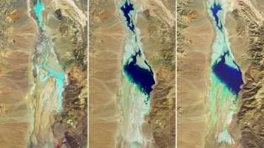
SWOT Satellite Helps Gauge the Depth of Death Valley’s Temporary Lake


Data from the international Surface Water and Ocean Topography mission helped researchers to calculate the depth of water in this transient freshwater body.

None

Get the Android app

Or read this on NASA

Read more on:

Photo of swot satellite helps

swot satellite helps

Photo of temporary lake

temporary lake

Photo of Death Valley

Death Valley

Related news:

News photo

Navigating Cognitive Decline: Curved Walking and Depth Cameras Unveil Early Signs

News photo

Hydrological Anomaly: Death Valley’s Persistent Lake Explored

News photo

Ultra-dry Death Valley has a temporary lake thanks to extreme rainfall